Frequently Asked Questions
Which OS does VDatum run on?
-
I have the latest Java, however when I double click vdatum.bat, the command prompt window flashes for a split second and the application does not launch.
-
Running "java -jar vdatum.jar" at the command prompt window gives me "java is not recognized as an internal or external command, operable program or batch file".
Add the path of java.exe to the environment variable PATH. This requires a Window administration account. Or
Edit the vdatum.bat file in a text editor. Replace "java" with the path to java.exe. For example:
"C:\Program Files\Java\jdk1.7.0_45\bin\java.exe" -jar vdatum.jar Save and run this new vdatum.bat file.
I can't select any tidal datum, or NAD 27, NAD83(1986), NGVD29, IGLD85!
I recieved a result of -999999.0. What does that mean?
Why doesn’t VDatum provide tidal datums inland?
What are the VDatum bounding polygons and why are they utilized?
Providing separation between areas with different tidal characteristics. For example, barrier islands usually have stronger tides on the ocean side and weaker tides within the inland waterways. Separating such areas with a polygon that runs along the barrier island ensures that tidal datum transformations near the barrier island do not mistakenly interpolate values from both the ocean and inland sides.
Delineating the borders between adjacent VDatum regions. VDatum is developed on a regional basis, and the tidal datum transformation grids between adjacent regions will have a small overlap region. The polygons indicate where the separation between the regions is located so that the VDatum software can determine which VDatum regional application is to be used.
Excluding regions due to coastal morphological change.In areas experiencing coastal morphology change associated with natural causes, the polygons in VDatum may be defined such that certain areas will not have tidal transformations available. For example, if there is a breaching of a barrier island that didn’t exist when VDatum was developed, the tidal datums provided in VDatum in the vicinity will become less accurate. For locations that are identified with such uncertainty in the current position of the shoreline, the polygons may be adjusted to not allow transformations to be returned by the VDatum software. Users should use VDatum cautiously in areas they know to be susceptible to such changes.
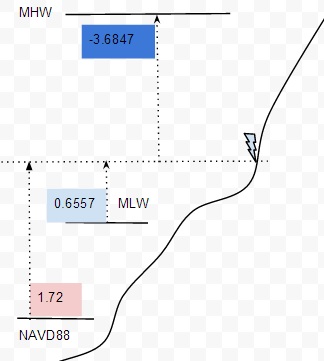
While trying to convert from NAVD88 to MLLW, MLW, MHW, etc.. I got results showing that the MLLW and MLW are higher than MHW and MHHW. Could it be program bug or something mixed up?
- NAVD88: 1.72m
- MLW: 0.6557m
- MHW: -3.6847m
As written in Java, VDatum runs on Mac OS X, Unix, VMP and Windows.
Please run java -jar vdatum.jar at the command prompt to get the error messages.
If Java has not yet been installed:
Please visit http://www.oracle.com/technetwork/java/javase/downloads/index.html
If Java is installed:
The message means that Java has not yet been added to the environment variables, PATH.
First, find out which directory that Java, i.e. java.exe, is installed. Usually in Windows it's in Program Files\java\jdk (some version numbers)\bin. Or search for "java.exe" from Explorer. If no java.exe is found, please do a fresh install of java.
Once you find the location of this file, you could either:
Conversions to or from these datums are calculated based on transformation grids. Please follow the Step-by-step Installation instruction to get the idea of what transformation grids to download from our website.
The -999999.0 is the no-data-value in our program. It occurs in areas where the transformations are invalid. In the tidal transformations, this -999999.0 value could mean that your elevation data are either out of the boundaries of our tidal transformation grids, or in the masked-out areas, i.e. inland or where are not covered by the tidal models.
Tidal datum transformations in VDatum extend only slightly inland of the mean high water (MHW) shoreline (1 or 2 km), but many applications seek to reference elevations to tidal datums further inland. The main reason that VDatum doesn’t provide tidal datums inland is the fact that tidal datums have no physical meaning inland (until or unless that inland location becomes inundated by tides).
One example is the application of VDatum to lidar data to compute a shoreline referenced to a tidal datum. Lidar data collected near the shoreline during low tide can be processed in VDatum and referenced to MHW. The resulting contours of the MHW-referenced data at a value of zero will then represent the MHW shoreline. If the tidal datum transformations do not extend far enough inland to make this transformation, though, users must make decisions about how to manually readjust the datum transformations to enable the shoreline computation to be made. Another example of a need to extend tidal datum transformations further inland is provided by sea level change studies. Such studies require static assumptions to determine which inland areas of a digital elevation model (DEM) would be influenced if coastal sea level was adjusted by a fixed amount. If the DEM heights are referenced to a tidal datum, then transformations are necessary in inland areas affected by sea level rise scenarios.
Spatial variations in tidal datums in coastal waters near shore can influence the method of approximating their inland extension. Tidal datums along a coastline can vary locally for many reasons, some of which include variable bathymetry, the presence of tidal flats, river interactions, presence of barrier islands, geographic/volumetric changes in the shoreline and associated embayments, and the presence of shoreline engineering structures. If none of these factors affects a given area (e.g. straight coastline, absence of other factors mentioned above), tidal datums should be relatively uniform along the coast.
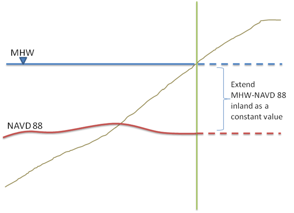
If tidal datums are relatively spatially uniform, extrapolation of the tidal datums can usually be made by assuming a constant datum difference which can be extended inland to a limited distance. For example, the figure below shows how a constant offset between NAVD 88 and local mean high water (MHW) could be extended inland if the project area is just inland of the VDatum model grid. In this manner, land or marsh elevations referenced to NAVD88 can still be related to the nearby MHW elevation.

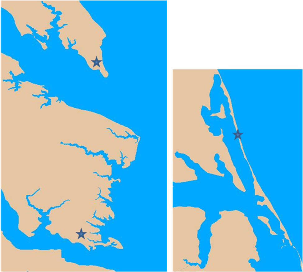
Often, however, tidal datums are not relatively spatially uniform, so most scenarios encounter some level of complexity due to the factors affecting local tidal datum variations. Therefore, some assumptions need to be made, while also acknowledging the uncertainty that can arise due to the associated factors. For example, the figure below illustrates several inland locations for which decisions would need to be made on how to extrapolate tidal datums inland. The star symbols in these figures indicate the inland locations in question, with sections of Chesapeake Bay on the left and of the Outer Banks of North Carolina on the right. These locations present a problem because they are close to at least two different bodies of water which are likely to have different tidal datums.

No matter what decision is made on how to extrapolate the tidal datums in such situations, it is suggested that statistics be computed on the variability of the datum transformations in the user‘s area of interest. For example, the constant offset assumption could be used with data from several separate coastal locations, resulting in several sets of offsets over the land region, each using a different datum value. From these sets, a statistical mean and variation could be computed. This information can then be used to document the uncertainty introduced by assuming a certain interpolation scheme or even by using a constant offset value. In some cases, the variability in transformation values between different regimes (river, bay, ocean, marsh, tidal flats, etc.) may be small enough in relation to the coastal issue being addressed.
There are additional caveats. In extending tidal datums inland for sea level change (SLC) studies, the assumptions of how that change will occur need to be considered. For example, if sea level rises by a constant amount in a region, the tides will also change due to new areas now being flooded or dried. The local tide patterns used to construct VDatum may no longer be completely applicable if significant changes occur as a result of a sea level change scenario. For example, a barrier island may be so low that in certain sea level rise scenarios some parts of the island would be breached. This changes the flow of water significantly, allowing the tides to more easily propagate into the inland waterway. Marshes and tidal flats can likewise be flooded and/or dried in sea level change scenarios, thus changing the local tidal datum patterns accordingly. Aside from the static effects of these SLC scenarios, dynamic influences related to morphological changes to the marshes and shoreline environments would also be present. Sediment erosion and marsh accretion would change in ways that could only be evaluated through detailed studies that link processes across a variety of scales together in a physically realistic manner.
Quantifying how all of these static and dynamic effects could change tidal datums extended inland is a difficult task. In many cases, it may be more appropriate to make an assumption of a constant datum transformation offset to be used for the area of interest, while acknowledging these effects in the documentation of the uncertainty. A constant offset, (e.g. between NAVD 88 and local mean sea level or mean high water ) could be determined by examining an offshore average difference between these two datums, far enough away from local factors affecting the nearshore tidal datum patterns. This offset could then be applied to transform topographic land heights from NAVD 88 to local mean sea level and/or mean high water.
Bounding polygons are now provided with each VDatum regional grid to define its area of valid transformations. There are several reasons that these polygons are needed to provide the user with the correct vertical datum transformation values, including:
|
No, it isn't a program bug, nor a mix up. Let's consider the diagram on the right, assuming a point (at the lightning bolt) has following elevation values (height values): where the original elevation value is relative to NAVD88 (1.72m). Using VDatum to get elevation values referenced in MLW (0.6557m), and in MHW is (-3.6847m). Since the origin of MHW is above the origin of MLW, the elevation result of MHW will be less than that of MLW. |  |
